Ursula Sadiq

"Hey, how did I get here?", asks the once and future geek. "Each step made sense along the way, didn't it?" Didn't it?

  • Followed
  • Follows you

Edit biography

I’m isolating. So I took myself for a long drive into the countryside. It wasn’t an aimless drive, I had a quest. I was looking for a Mason-Dixon stone. 

The western border of Delaware southern terminus is at the Transpeninsular line, at a point half way between the Atlantic Ocean and the Chesapeake Bay, along a latitude line starting at Fenwick island. This was a mistake, it was supposed to start at Cape Henlopen, but in 1732 Lord Calvert submitted the wrong map to the presiding English court establishing the border. The erroneous map labeled Fenwick as Cape Henlopen, so the line started about 24 miles south of where it should have been. This had the effect of making William Penn’s Delaware bigger and Lord Calvert’s Maryland smaller by about 1000 square miles (which is like 40% of Delaware. Delaware is only about 2500 square miles in size today. )

Anyway, half way along this Transpeninsular latitude line is the midpoint, which I visited in a previous post.

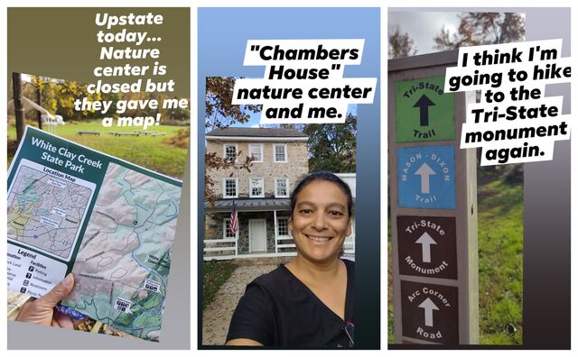
Way up in northern Delaware, a 12 mile circle was drawn around the town of New Castle. The western border of Delaware goes from the Transpeninsular midpoint to a point tangent to the 12 mile circle. This Tangent Line does not go “true north” in longitude but slants ever so slightly westward to hit the tangent point. Once the border hits the 12 mile circle, it heads true north* to 39°43′20″ N, which is the latitude to the Maryland-Pennslyvania border. This is the Tri-State marker point, found in White clay creek park**.

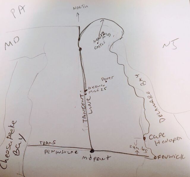
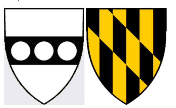
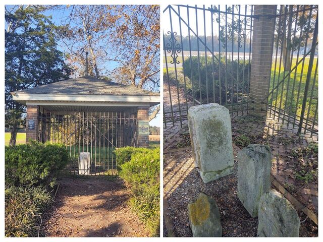
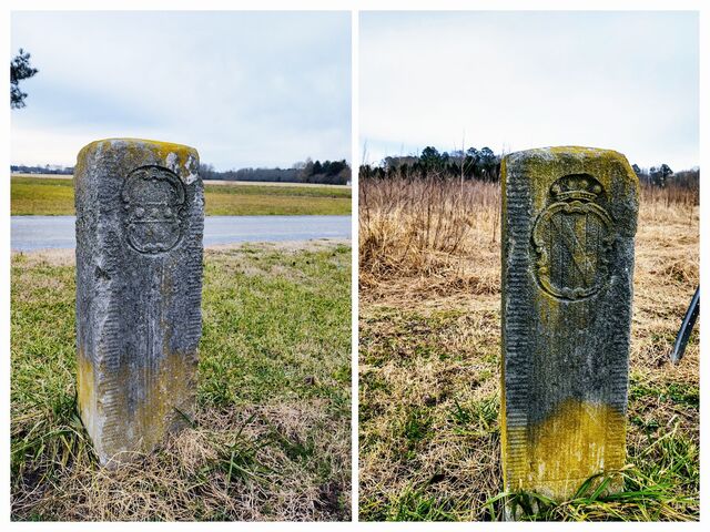
Anyway, Mason & Dixon put markers down every mile along the Tangent Line, which every 5 miles dropping a more ornate Crownstone, carved with the crests of both Penn and Calvert. I decided to go look for one or two of these markers. 

So I drove out the Hickman Delaware, about 40 minutes from Dover. I had recently received a book called East of the Mason-Dixon Line by R. Nathan. The text is available online too, at https://archives.delaware.gov/wp-content/uploads/sites/156/2018/08/East-of-the-Mason-Dixon-Line_-A-History-of-the-Delaware-Boundaries-Roger-E.-Nathan.pdf

Page 95 talks about how to locate these two monuments, but vaguely - it doesn't give actual coordinates or directions. I have since found a much MUCH better source. It's called waymarking.com. Searching on MASDIX Tangent gets you all the markers and how to find them!! It's going to be a fun quest now!!!

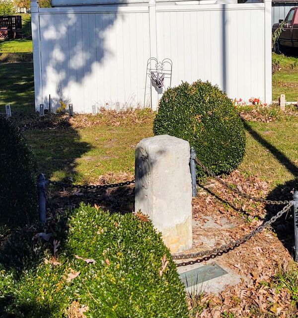
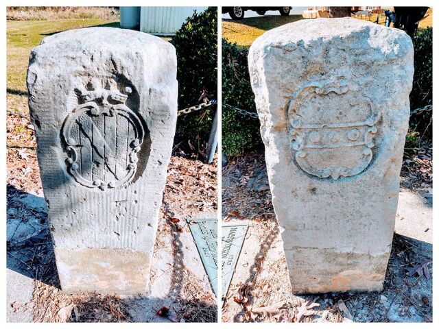
Anywho, the Crownstone at mile marker 25

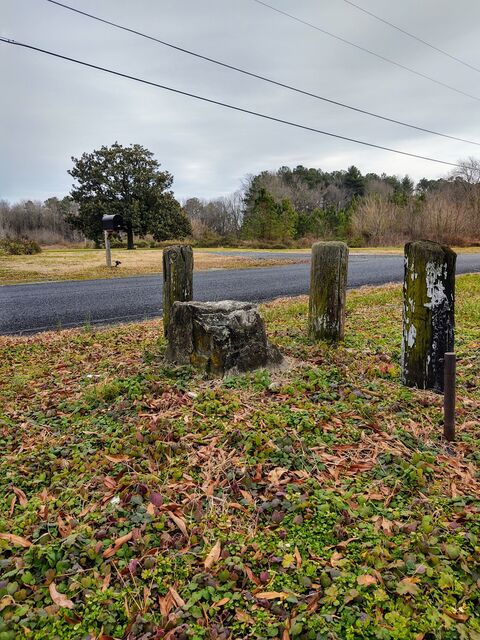
And the sad worn marker 26 one mile north in Hickman proper

Proverbs 22:28 : Remove not the ancient landmark, which thy fathers have set.

*actually, the border follows the 12 mile circle for just a wee bit more before turning north. This gives Delaware an extra 0.02 square miles. Apparently the 12 mile circle trumped the north line in the negotiations of border location.

** Today the MD-PA line goes straight to the arc, and the little wedge was given to Delaware. But that happened later, around 1920. I didn't draw that on my map sketch.

MORE
1/10 '21
 

In a lovely November weekend, I head out to my local winery. While buying a case, I notice there is a photo of a Mason-Dixson crownstone framed on the wall.

I get excited. “You have a Mason-Dixson stone! Can I see it?!!?”

Alas, I was informed, it’s on the owner’s property, and not available for public viewing. Except EXCEPT, occasionally when they do the behind the scenes vineyard tours. Which they aren’t doing now due to Covid, but expect to do so again. As one of the workers there carried my case out, he took me to the side and pointed out where the stone is - in the distance, behind the vines, under a tree. 

I am so going back for the Vineyard tour.

Mason and Dixon and crew placed "crownstones" every 5 miles, way back in 1763. Smaller stone markers were placed in the inbetween miles. The stones were quarried in England, and crown stones were engraved with the crests of the two great houses that commissioned the survey: House Penn and House Cavert. (Calvert was also Lord Baltimore, and the Maryland state flag has this same graphic on two quardrents of its flag)

Five miles north of the Harvest Ridge Winery is the town of Marydel, on the border of Maryland and Delaware. In an unassuming spot by the road is a little chain marked square, with a crownstone inside. My understanding is that this marker was removed and displayed in St. Louis in 1904, and later in Baltimore. It was returned to Marydel in 1954 and was reset in 1964. So it may be a few feet off the original spot. 

The next day, we traveled south to the south western most point of Delaware. I planned the route to take us across on the Woodland Ferry. (Google maps doesn't realize this ferry is an option, so you have to convince it.) Apparently this ferry has been running since 1743ish, by the Cannon family, who were eventually granted “exclusive ferrying rights”. The Cannons ran the ferry for 100 years, among other business ventures. The Deldot brochure on the ferry mentions a jilted groom, strongarm foreclosures, slaving, and honey disputes that end in death. Apparently the Cannons were assholes, and their demise was not mourned. The county and eventually the state took over the ferry, which is free to use today. It’s about a 2 minutes crossing and can fit 4-6 vehicles at a time. (And from my home in Dover to the southwest corner of Delaware, only a 5 minute detour from google’s “fastest route”.)

Anyhow, at the south western most point of Delaware there is - you guessed it - and monument placed by Mason & Dixon. It is another crownstone, called the Transpeninsular Midpoint Marker and it is much better protected than the Marydel one. Also in the protective cage are 2 smaller survey stones done by other surveyors before Mason & Dixon came around. Mason & Dixon verified the earlier survey work. There is ALSO a third smaller stone, which apparently is just there because when they were building the cage, a local had it, thought it looked similar and belonged with the others, so put it with them. Another point for my Delaware is Awesome tally.

People throw change into the cage. Dunno why. We left our 2cents and moseyed on.

MORE
11/9 '20 3 Comments
Out of 24 county equivalents in Maryland, exactly half are named for people directly related to the Calvert family.
Cool! History is cool.
I am trying to engage my kid on seeing the connections. Astronomy! Surveys! Taxes! The crests! The Flag!
Ferrys before Bridges! ... mostly she just roles her eyes at me. But I'm hoping some of it sinks in.

She did seem to perk up when I said that Jeremiah Dixon was a miscreant that got disowned from the (Quaker) church. But I'm hoping she remembers the other stuff too
Some of it will sink in. Says the guy whose father dragged him to every civil war and American revolution battlefield in driving distance.
 

My research of Mason-Dixon markers on the Delaware Border. All of which I plan to go see in the near(ish) future.


MORE
10/29 '20 1 Comment
 

At the northwest corner of Delaware, where it meets Pennslyvania & Maryland, is the “Tri-State Marker”. It was first located by Mason and Dixon back in 1765, though the marker was placed later, in 1849. I learned pretty much everything I know about it from this newspaper article from 2015: https://www.newarkpostonline.com/news/new-trail-provides-first-public-access-to-mason-dixon-tri-state-marker/article_a5ec3a04-fe1a-58d4-a317-93c3e887c863.html

I’ve hiked to the marker twice this year, from Delaware's White Clay Creek State Park starting at the Chambers House Nature Center parking lot. It’s about a 3.5 mile roundtrip, meaning an hour and a half walk for me. I walk slow, and stop to look at things a lot. I had the path mostly to myself when I hiked it Friday afternoon, saw just 6 others in the 1.5 hours I was walking.

I understand you can also walk to the monument through other shorter pathways, but I haven’t done so. That’s an adventure for another time.

Note: The Chambers House nature center is also the location of one of the Selfie spots for the Delaware State Parks passport program. It's still closed due to COVID, but I saw some staff heading in to work. They arehoping to repoen in January. They gave me a map, and seemed to think the walk to the monument was "far". 

Trip start

OUTBOUND

Trail is mostly wooded trees, but it does open up to a field or two upon occasion. You cross from Delaware to Pennsylvania pretty early in the hike. And yeah, I bough hiking boots (Merrells). Last time I hiked this in the Spring, I had just bought hiking sandles (Tevas), which I love. But it's getting too crisp for sandles.

THE MONUMENT

I later learned (from reading that article above) that the monument has no D because in Mason-Dixon's time, Delaware was still part of Pennsylvania. Hence 2 P’s , 2 M’s no D.

THE WAY BACK

On the way back you cross into Delaware, then back into Pennsylvania, then back into Delaware.  Also, there is a peace love & happiness tree (Yo peeps: don't graffiti trees, even with nice sentiments). I understand there is a CAVE near one of these PA/DE borders, on the PA side. Something to look for next time.

So, pretty easy hike, cool historical marker, not crowded. Recommended.

MORE
10/28 '20 3 Comments
A beautiful day for hiking. If you ever lack things to look for, https://www.geocaching.com has thousands, including https://www.geocaching.com/geocache/GC1EN31 in White Clay Creek State Park.
I just today learned about letterboxing. Which sounds like fancy geocaching... I might give that a try
Yeah, letterboxing long predates the practice of "using multi-million dollar satellites to find Tupperware in the woods".